Kolhapur (Kolhāpur)
Kolhapur is a city on the banks of the Panchganga River in the southern part of the Indian state of Maharashtra.
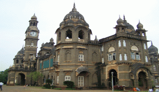
Kolhapur, an epitome of beauty and richness in the Indian state of Maharashtra, stands tall as one of the most significant cities in South Maharashtra. With its rich cultural heritage, this city has been a hub of historical, religious, and cultural activities for centuries. Its historic significance can be traced back to the 1st century BC and continues to amaze visitors with its intricate carvings and magnificent temples. Kolhapur is famous for its unique food culture, including its signature Kolhapuri cuisine, that tantalizes the taste buds of locals and tourists alike. Sports, arts and local dialects also play a major role in defining the identity of the city, making it a true representation of diversity and unity. The city is situated in the western part of Maharashtra and is often referred to as "Dakshin Kashi" or "Mahateerth". It boasts a rich history, which has given it various other names, including Kollagiri, Kolladigiripattan and Kollpur, all meaning "valley". The vibrant and rich city of Kolhapur is indeed a cultural treasure, waiting to be explored by those in search of a true taste of India.
Kolhapur district. Around 2 C.E. Kolhapur's name was 'Kuntal'.
Kolhapur is known as 'Dakshin Kashi ' or Kashi of the South because of its spiritual history and the antiquity of its shrine Mahalaxmi, better known as Ambabai. The region is known for the production of the famous hand-crafted and braided leather slippers called Kolhapuri chappal, which received the Geographical Indication designation in 2019. In Hindu mythology, the city is referred to as "Karvir."
Before India became independent in 1947, Kolhapur was a princely state under the Bhosale Chhatrapati of the Maratha Empire. It is an important center for the Marathi film industry.
Kolhapur is named after Kolhasur, a demon in Hindu History. According to History, the demon Kolhasur renounced asceticism after his sons were killed by God for harassing people, and prayed to Mahalakshmi that she would leave the area to him for a hundred years. He committed numerous crimes until the goddess returned after the hundred years were over and killed him for his sins. The dying wish of Kolhasur was to name the place after him, which was granted and the place was named Kolhapur. Kolha stands for Kolhasur and pur, a Sanskrit word, means "city".
Map - Kolhapur (Kolhāpur)
Map


Country - India
 |
 |
| Flag of India | |
Modern humans arrived on the Indian subcontinent from Africa no later than 55,000 years ago. Their long occupation, initially in varying forms of isolation as hunter-gatherers, has made the region highly diverse, second only to Africa in human genetic diversity. Settled life emerged on the subcontinent in the western margins of the Indus river basin 9,000 years ago, evolving gradually into the Indus Valley Civilisation of the third millennium BCE. By, an archaic form of Sanskrit, an Indo-European language, had diffused into India from the northwest. (a) (b) (c), "In Punjab, a dry region with grasslands watered by five rivers (hence ‘panch’ and ‘ab’) draining the western Himalayas, one prehistoric culture left no material remains, but some of its ritual texts were preserved orally over the millennia. The culture is called Aryan, and evidence in its texts indicates that it spread slowly south-east, following the course of the Yamuna and Ganga Rivers. Its elite called itself Arya (pure) and distinguished themselves sharply from others. Aryans led kin groups organized as nomadic horse-herding tribes. Their ritual texts are called Vedas, composed in Sanskrit. Vedic Sanskrit is recorded only in hymns that were part of Vedic rituals to Aryan gods. To be Aryan apparently meant to belong to the elite among pastoral tribes. Texts that record Aryan culture are not precisely datable, but they seem to begin around 1200 BCE with four collections of Vedic hymns (Rg, Sama, Yajur, and Artharva)."
Currency / Language
| ISO | Currency | Symbol | Significant figures |
|---|---|---|---|
| INR | Indian rupee | ₹ | 2 |
| ISO | Language |
|---|---|
| AS | Assamese language |
| BN | Bengali language |
| BH | Bihari languages |
| EN | English language |
| GU | Gujarati language |
| HI | Hindi |
| KN | Kannada language |
| ML | Malayalam language |
| MR | Marathi language |
| OR | Oriya language |
| PA | Panjabi language |
| TA | Tamil language |
| TE | Telugu language |
| UR | Urdu |